Itinerary
Acropolis of Populonia
Introduction (Meeting Point)
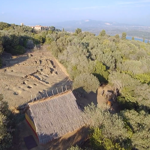
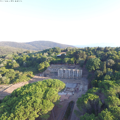
Welcome to the Archaeological Park of Baratti and Populonia, where you can admire the archaeological remains of one of the most famous ancient Etruscan towns and some of the most beautiful landscapes in Tuscany. Populonia’s geography, economy and millenary history were linked to iron working which, over the centuries, made it one of the most famous iron producing centres in the ancient world. Populonia’s origins are lost in the mists of time. Ancient sources speak of settlers arriving from Volterra and the island of Corsica and building a new city on this hill – a version that seems far too simplistic to be believed. Recent archaeological evidence from the 10th and 9th centuries BC, on the other hand, reveals that people moved from the inhabited villages towards the hills and valleys on the promontory between the Gulf of Baratti and the Gulf of Fallonica. Unfortunately, we know very little about the nature of these pre-Etruscan villages and the relationships between them. However, on a hill called Poggio del Telegrafo (Telegraph Hill), not far from where you are now, archaeologists have recently discovered holes of different sizes into which were driven structural posts which supported huts built by the area’s original inhabitants. Unattractive from an aesthetic point of view, the post holes are crucial for understanding the shape and composition of the village. The fact that some huts were of considerable size, along with the discovery of imported pottery, has led us to believe that an early-elitist society ran the economy and politics of the area. The reconstruction of the floor plan of one large rectangular hut reveals that it even had a porch. Having being used by the community as a public meeting place, the hut was demolished between the 8th and 7th centuries BC in order to build a similar one, accompanied by the careful deposition of about 100 cups stacked on top of each other in one of the holes used for the structural posts. The interpretation of this ritual gesture is still a matter for debate; one could however imagine a change of leadership of the town - perhaps a much loved king had died and, after celebrating the event with a sacred toast, the hut was demolished and the ceremonial cups were buried. Another theory is that the king had revealed himself to be a tyrant, his eventual death being celebrated by welcoming the rise of a new sovereign. Whatever its true meaning, this rite provides further evidence that the Etruscan town of Populonia was founded on Poggio del Telegrafo (Telegraph Hill). A few centuries later, the hill was completely inhabited and was the highest and most important area of the Etruscan town of Puplùna. No longer a small nameless village defended by a palisade, now it contained shops, temples and, perhaps, public buildings overlooking busy squares full of people. Populonia was home to thousands of people who worked iron which was imported from the island of Elba and copper from the Campiglia mines in the furnaces of the lower city. Even today, after more than two millennia, you can easily find traces of the town’s ancient industrial processes on the beach of the Gulf of Baratti – brilliant hematite powder and dark iron slag – the remnants of an old industrial town which had become deforested, polluted and full of waste dumps. Unfortunately, nothing remains of the Etruscan Acropolis, the highest part of the town which must have been a small paradise. The Romans took control of the town in the 3rd century BC and, unfortunately, during their great urban restructuring in the 2nd century BC, they forever obliterated all traces of the Etruscan settlement. Let's stop for a moment. Romans and Etruscans clashed on the battlefield on many occasions and it’s easy to imagine great, epic battles, sieges and destruction for the possession of the rich land of Etruria. Archaeological research has not revealed any clear evidence of destruction, however, meaning that Populonia must not have had the strength to oppose the power of Rome, and that local Etruscan aristocracies most likely aligned with the new power in order to retain their role in the city. The wealth of the burial goods from this period and the continuous production of iron demonstrate a renewed economic impulse, initially and indirectly, at least, under Roman rule. The recent excavations are slowly bringing the Acropolis back to light, everything that is visible in today’s open archaeological site having been built by the Romans during the 3rd and 2nd century BC. So much remains to be discovered about the urban complexity of the town’s highest point which, during the coming years, will undoubtedly reveal many more surprises.
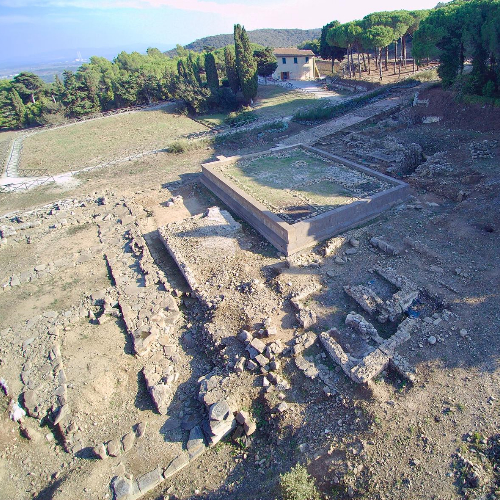
The Sacred Area (between Temple A and Temple B)
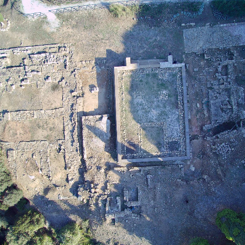
We have just entered what used to be the sacred area of the Roman Acropolis of Populonia where, so far, three great temples have been unearthed. Unfortunately, little remains of the ancient splendour of these temples – only their bases are visible because, in the Middle Ages, the blocks with which the temples were built were disassembled, one by one, and used to build new buildings, for example Populonia Castle. Here, in the area in front of the temples, great religious functions took place and the citizens of Populonia would have witnessed sacrifices to the gods on altars facing the temples. No one, not even the richest inhabitant, could enter the temples apart from the priest, the intermediary between the sacred world and the real world. Temple A was built in sandstone and had an intimate shape – a small portico with only 4 columns separating the cella, the central room, from the external space. Unfortunately, the divinity to which it was dedicated remains a mystery, however. From the cavity in the foundations of the temple, it is evident that there was a place of worship on this site prior to the Roman temple, which, thanks to the discovery of some sculpted heads, dates back to the-2nd century BC. Magnificent and imposing, Temple B is the largest of all the temples to have been excavated so far. Unfortunately, part of the temple has collapsed but, from the foundations and the surviving steps, it is still possible to appreciate the ancient grandeur of this highly impressive building which was built between the 3rd and 2nd century BC. The existence of three large rooms immediately led to the hypothesis of a triad, later confirmed by the discovery of fragments of sculptural decoration: a character in the claws of a bird of prey. This was the first clue that led to the identification of Temple B with the Capitòlium of Populonia, the most important temple dedicated to Jupiter, Juno and Minerva. The fragment refers to one of the most famous myths of the Greco-Roman world: Jupiter, in search of one of his usual extra-marital adventures, falls madly in love with the young Ganymede, who he kidnaps by transforming himself into an eagle and taking him to Olympus to be his butler. Pliny the Elder, a Roman author who died in the eruption of Vesuvius in 79 AD, documented that, in Populonia, there was an ancient statue of Jupiter made from vine wood from Cyprus, thus confirming the existence of the cult of Jupiter in the town.
A Small Temple – Hadrian in Populonia
As a show of support towards the ancient allied city of Rome and in deference to the gods, during the reign of the Emperor Hadrian, the temples of Populonia were restored and the small temple you see before you was built. Dating back to around 50 BC, the temple was built on the site of an older building, and consisted of two rooms and a stereobate with three steps. How do we know this? While excavating the area in front of you, archaeologists found the floors of the rooms, which are made up of small fragments of white marble and mortar. The perimeter walls were largely dismantled and the blocks used as building material in the Middle Ages. In fact, at the front, only one row of stones was left, on which the first of the three steps of the entrance staircase was built. When the floor of the first room was excavated, an accumulation of rubble from the temples, evidently already in ruins when the temple was built, was found underneath. Among these ruins were ceramics dating back to between 80 and 120AD, corresponding with a fragment of a marble inscription found in the area of the temples. Although the fragment is small, it is big enough to read the Emperor Hadrian’s name and part of a ritual phrase used to celebrate the restoration of ancient buildings. The complete inscription was probably located on the front of the small temple facing the large square, and would therefore have been easily legible by anyone travelling through the sacred area of the acropolis at that time. The inscription on the fragment reads: THE EMPEROR CAESAR, SON OF THE DIVINE TRAJAN, VICTOR OF THE PARTIES, GRANDSON OF THE DIVINE NERVA, TRAJAN HADRIAN AUGUSTUS, PONTIFF MAXIMUS, 9 TIMES TRIBUNE OF THE PLEBS, 3 TIMES CONSUL, HAS RESTORED (THIS BUILDING) RUINED BY TIME.
Temple C
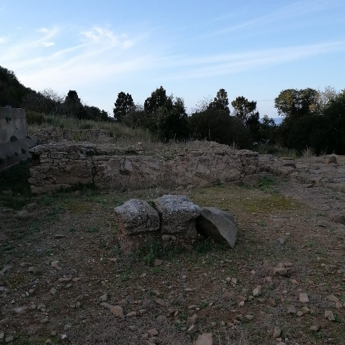
From a conservation and legibility point of view, the third of the three temples was the most complicated because only very few blocks remained in situ. Thus, the temple was chosen for an innovative, non-invasive reconstruction project, which involved the original podium. Blocks of industrial polystyrene covered with synthetic resin and lined with blocks of calcarenite were faithfully produced to copy the size, colour and shape of the blocks used in the original construction of the ancient temple, and the access staircase was rebuilt in rhyolite. These interventions have restored the ancient temple to its former state, stimulating the same feelings of awe people must have had when standing in front of it in Roman times. Built between the late-3rd and the early-2nd century BC, shortly before Temple B was built, Temple C was a Tuscan temple with three rooms which stood on a podium 1.83m high on which there were two rows of two central columns in the pronaos, closed at the sides by antae (light doors). The temple was accessible by steps: 5 wider steps at the bottom (7.96 m wide) and then successive 3 steps at the top (4.40 m wide), with a total of 9 risers to reach the level of the temple. The base was 16.08m wide (54 Roman feet) and 21.35 m long (72 feet, 77 if we consider the steps), a total length of 22.87m. The inner walls measured 7.5 feet (2.29m), creating a space which was divided into three rooms, a larger central room and two smaller lateral ones not exactly the same size. Unfortunately, the excavations have not clarified whether the lateral rooms were closed off from or communicated with the central one for the deposition of votive offerings and sacred objects. If the rooms were separate, Temple C was probably dedicated to three different divinities: a main one housed in the central room, and two minor ones in the side rooms. Judging by the ears of wheat, pomegranates, vine shoots and quinces depicted on the surviving fragments of the temple’s decoration, the triad is identifiable as Ceres, Libero and Libera, three divinities linked to the cycle of the seasons. If, however, the rooms were adjoining, the temple was almost certainly dedicated to a single divinity, perhaps Heracles. A mirror from Orvieto probably depicts Heracles, who was associated with Fùfluns, the Etruscan god of wine, happiness and growth. If so, the plants depicted are not a simple decoration, but represent Heracles’s role as protector of the growing cycle of plants. This would also explain the depiction of a winged spirit, the personification of the force of nature associated with both the earthly and the spiritual worlds, and the bunch of grapes, associated with Fùfluns, on the decoration of the mirror. The sculpture of a hand, an anatomical votive offering, as well as fragments of pozzola deòrum, were also found nearby, yet more evidence pointing to Temple C’s dedication to the worship of Heracles, who had already featured in Populonia in earlier times, and who may have found a new place of worship here in Roman times.
The Cistern & the rear of Temple C
At the back of the rebuilt Temple C, you can see the original blocks of calcarenite, used to face the outside of the structure which had a sandstone core. Other buildings, probably linked mostly to cultic activities, can be seen near the temple. A few steps left take you to the large cistern, an enormous rainwater collector (holding up to 500m3), which is still partially to be excavated. The rainwater was channelled to the cistern by an extensive underground network of channels which ran below the buildings on the acropolis. In fact, Populonia was devoid of natural water sources so every single drop of rain was meticulously collected to ensure the continuity of the town's water supply. In a world in which every aspect of life, including construction, was imbued with the sacred, Populonia’s impressive urban transformation was almost certainly accompanied by ceremonies and celebrations. This is evidenced in the votive deposition of a dish with the remains of piglets in it, probably a sacrifice which included the collective ritual consumption of meat in the complex of the large public cistern in the city. A sacred element, water could not be imprisoned by the works of man, nor its natural course diverted for the needs of mortals without the gesture being celebrated, not to mention the act of profaning the earth when people came into contact with resident deities. Curiously, the cistern experienced a second more 'recent' life after the progressive abandonment of the Acropolis in Roman times (1st century AD). Covered by a double-barrel vault, the large underground room was equipped with a monumental access staircase made of slabs and blocks of calcarenite, on the sides of which there were niches. The cistern no longer had its original function as a water collector and, due to its underground setting, was perhaps used as a place of worship in the late-Roman imperial era, the most fascinating hypothesis being linked to the cult of Mithras. Despite its changing role, the area of the acropolis survived for centuries. A small settlement was founded in the area behind Temple C on top of the abandoned Roman acropolis in the 9th century AD, which would suggest an attempt to escape the frequent incursions of Saracen and Greek pirates and brigands along the coast. So far, two wooden houses with fireplaces, some caisson tombs, and even a small road have been identified in the 9th century settlement.
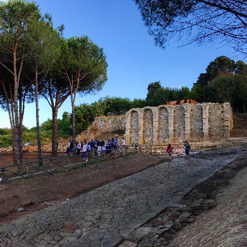
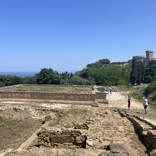
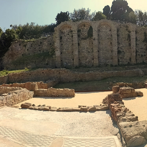
The paved Road
Stretching out before us is a magnificent, extremely well-preserved Roman road, part of a gridiron network of roads making up the urban plan of the city, which hides many more secrets than you might think. The Romans usually built roads to facilitate the movement of powerful armies, to facilitate trade and commerce, and to make a town generally more organized and liveable. This road, however, is far too short to have been of use to the army, and is too steep (about 11%) to have been used by wagons – in fact, there are no deep ruts, typical of the continuous passage of wheels, in the surface of the road. So why was this short road built? It was probably a road for use on solemn occasions, built to connect the sacred area of the temples with the arched building on terraces that can be seen at the end of its route, probably a maritime sanctuary dedicated to Venus. It was, therefore, a sacred road. The street was flanked by a sidewalk made of large blocks of calcarenite, and there were buildings on either side. At some points, it is possible to glimpse the secondary road axes perpendicular to the main road, also paved with stone, which define the streets and neighbourhoods of the acropolis. Below the street, a large central rainwater collector and a complex system of canals and small cisterns conveyed water downstream towards the large city cistern.
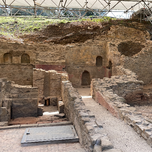
The Domus
You are currently standing in front of the most luxurious domus (Roman house) in ancient Populonia, one of the largest in the whole of Etruria! The house directly overlooked the town’s main road, which descended towards the temples, so its owner must have been a very prominent figure and would have lived here with his family and house slaves. The house was large and articulated because it had to perform many different functions. There were separate family and slave quarters, as well as service areas such as the kitchen and pantry. The most sumptuous rooms occupied the centre of the house in order to show off the owner’s prestige to visitors. The main entrance room was the atrium, from where occupants had access to all the other rooms, and where people (customers) gathered to visit the master of the house every morning in order to ask him for favours or do business with him. The owner would have invited his friends and distinguished guests into the other rooms and the garden at the rear of the house. The house was built around 100BC in place of an earlier, as yet, undated one. The small baths visible on the right of the building were added at a later time, perhaps when the floors we can still see today were made. The house was abandoned after a fire some 150 years after it was built, so only half of the house is preserved. From the street one entered the vestibule (A) and passed into the corridor (B) which led to the atrium (C). Continuing along the same alignment was the tablinium (D), a large living room opening into the atrium. There were two other lateral annexes of the atrium, called wings, of which we can see only one (E). To the right were the baths (F), and some service areas (G). The door at the end of the tablinum led to a garden (H), which also opened onto a vast room, perhaps a banquet hall (triclinium), (I) where the owner dined with his guests. In the center of the atrium, we can see the low basin of the impluvium (L) which collected the rain that fell from the rectangular opening in the roof (compluvium). The water collected in the impluvium ran into an underground cistern which was located under the garden. Some steps found in the service areas allow us to hypothesize that the house originally had a second floor (M).
Inside the Domus
Between 100 BC and 80 BC, two thermal environments were incorporated into the house for the hygienic practices of family members, and perhaps also for their guests. At the time, rooms with hot baths were still rare in family homes, so the addition of these private services to this house is another sign of the considerable wealth of its owners. The entrance to the baths was through a small room, which served to insulate the baths from the cold air from outside. This entrance room had clay walls (no longer visible) and was closed off by two doors, one providing access from the atrium, the other the way into the first thermal room. It was a very simple space with a cocciopesto floor, and was unheated, except perhaps in the winter by a brazier. It was used for changing before and after entering the warm bath room (caldarium), clothes being placed on a bench or shelves. On the right of the room, a dividing wall created a reserved corner, where there was a tub which was used for cleaning the bathroom or as a latrine. Unfortunately, the tub, which was recessed into the floor, was removed during one of the many stripping operations. From this entrance room, there were two steps up into the caldarium, through a beautiful checkerboard mosaic doorway. The bath room was raised because it was necessary to create space for the cavity (hypocaust), which is still under the floor, where the hot air produced by the oven (prefurnium) circulated in order to heat the room, before exiting through two small circular chimneys located in the corners of the wall adjacent to the road. The prefurnium (furnace room) was placed in the corner of the adjacent room and heated boilers filled with water which ran through pipes and filled the hot bath tub, which was located directly in front of the entrance to the prefurnium. Unfortunately, all that remains of the tub is the beautifully decorated access step. To the left of the step there is a semi-circular exedra, a small room with benches where people could sit and chat, which housed a terracotta or marble basin which rested on a base. The basin was filled with cold water which was used to cool off and mitigate the effect of the high temperature of the bath room. The exedra was furnished with benches arranged along the walls, where one could sit or lie and enjoy the heat and sweat, or receive massages with scented oils. Slaves provided the massages, as well as running the heating system and cleaning the premises after use. Simple, elegant decorations enhanced the pleasure of the environment: the semi-circular motif of the white limestone mosaic near the exedra forms a band representing city walls, which stands out from the central motif. The step of the exedra itself is decorated with a dense checkerboard motif, and the wall cladding is painted with red cocciopesto, embellished with white tesserae in order to form geometric motifs, such as on the riser of the steps to the pool. Without a shadow of a doubt, this private spa would have been the pride of its owners!
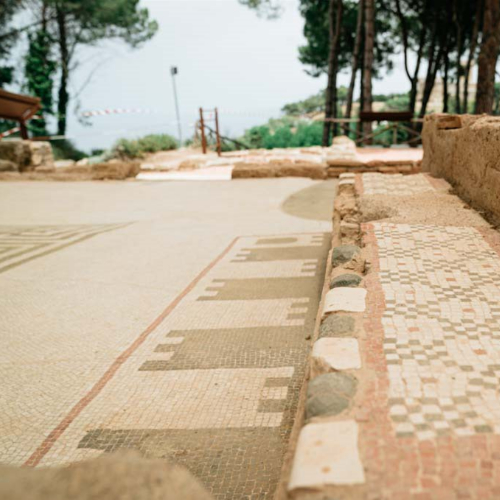
The Upper Terrace of the Loggias - the Belvedere
The upper terrace of the loggias (buildings open on one or more sides) had an extraordinary view of the street and the area of the temples. The belvedere (viewing point) had truly exceptional decoration, executed with great technical and artistic skill. Large brightly coloured squares painted on the walls replicated different types of marble interspersed with stucco half-columns which replicated marble ones. The coffered ceiling was painted red and white, whereas the floor was a white mosaic, bordered by a red band, and embellished with a central cube motif in marble slabs. When the building was abandoned, the Belvedere collapsed into the underlying room which was used as a warehouse. Archaeologists painstakingly unearthed hundreds of fragments belonging to a portion of the floor and its central motif, the study and restoration of which are now on display in the Piombino Archaeological Museum.
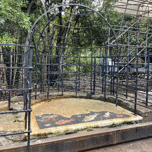
The Nymphaeum
On the upper terrace of the Loggias, the preserved remains of a monumental fountain dedicated to the Nymphs were found by chance by a farmer. The walls of the fountain were originally decorated with shells, two side by side niches recreating a marine environment. The mosaic represents a dark sea populated by fish and molluscs, with an illusionistic effect created by the fountain’s water flowing over the surface, which was then channelled into the two hypogean environments below the niches. The hypothesis is that this monumental fountain housed a chapel dedicated to Venus, the goddess of love and beauty, as well as the protector of sailors, as evidenced by the shipwreck scene of the mosaic. A boat with three sailors on board, one of whom is raising his arm towards the sky in the direction of what, at first sight, looks like a mollusc, is about to be overwhelmed by the waves. If the scene is observed upside down, the mollusc takes on the appearance of a dove, a bird sacred to Venus. The hypothesis is that the representation is an ex-voto (offering) to the goddess for the sailors to be saved from the shipwreck.
The Spa complex
On the terrace of the Loggia, archaeologists are bringing to light one of the oldest thermal buildings in Northern Etruria. Preserved in a truly extraordinary way and uncommonly high, the hypothesis is that they are public baths linked to the activities of the sanctuary of the Loggia, which was dedicated to Venus. The building was accessed from a narrow corridor with two doors, the second of which led into the room with the cold bath. The room was paved in opus spicatum, small terracotta bricks arranged in a herringbone pattern, and the terracotta tub for the bathroom is still intact. From there, one could enter the tholos (sauna), and, passing along a small corridor paved with a checkerboard mosaic, the caldarium, the room containing the hot bath. Only the walls of the caldarium, with storage niches, and the level below the floor, on which brick pillars were placed at regular distances to support the actual caldarium floor (a polychrome mosaic found by archaeologists in pieces), survive. The mosaic floor was intentionally destroyed in order to recover the good quality bricks that supported the floor. The recovered bricks were used to create a cavity in which to channel the heat from the prefurnium (furnace), which was located in a separate and inaccessible service room adjacent to the caldarium, the whole heating system being called the hypocaust. The baths’ service personnel took care of the fire, and the supply of wood, coal and water. Even the hot bath tub, located very close to the prefurnium, was removed to recover the metal that lined it. In one of the niches of the caldarium, there is an extraordinary polychrome mosaic, depicting two busts of Ethiopians, their turquoise robes, closed by a gold brooch, suggesting that they were not slaves (often used for service in the baths), but that they may have instead been characters linked to the cult of Venus.
The defense system of Populonia
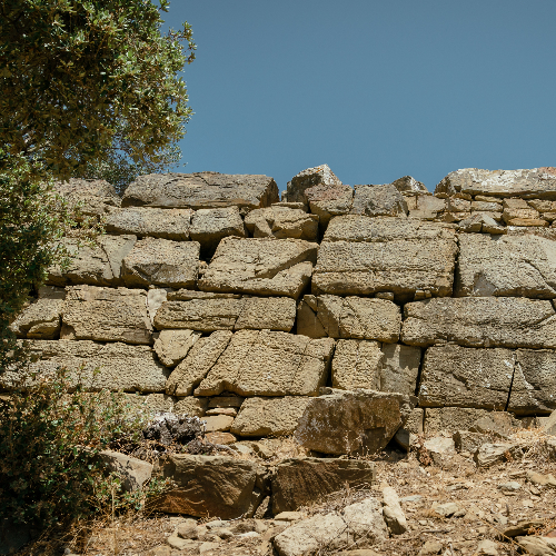
With the islands of the Tuscan archipelago on the horizon, Populonia was the only coastal Etruscan city, the stretch of sea that lies in between also being controlled by the ancient city. Indeed, Populonia’s wealth came from the sea. Hematite, iron oxide from the Island of Elba, was imported on large, fast ships, transported from the port to the industrial districts of the town, and then transformed into iron, for use in weapons and agricultural and industrial tools. The upper city was protected by a massive wall made of polygonal sandstone blocks, which followed the contours of the promontory and enclosed a path about two and a half kilometres long, enclosing the hills of the castle and Poggio del Telegrafo (Telegraph Hill). The high walls were part of a complex fortification system of high walls, which protected the Acropolis, the heart of the city, and site of its public and sacred buildings, and low walls, which defended the city from the Gulf of Baratti (to the north) to Cala San Quirico (to the east). These two walls surrounding the city were also linked together by connecting walls, as can be seen in a preserved structure on Poggio della Guardiola (Guardhouse Hill) – a large walkway, delimited laterally by walls, similar to the ones in Cuma, Syracuse and Selinunte, the most complete and monumental defensive tunnel systems of the 4th – 3rd century BC. The dating of Populonia’s defensive system is still uncertain. At first, it was thought that the high walls had been built between the 6th and 5th centuries BC, as in other flourishing Etruscan cities in that period. The construction of the walls would therefore have coincided with the situation of great instability in the Tyrrhenian Sea during the Syracusan and Punic invasions. The low walls, on the other hand, were thought to have been built in the 4th century BC to protect the town that had spread from the high walls in Populonia to the industrial and port districts, located near Baratti. However, recent archaeological research linked to the construction of the path you are standing on has rewritten this hypothesis, dating the entire defensive system of Populonia to between the late-4th and early-3rd century BC, when Populonia had already capitulated to Rome, which was in the process of conquering the whole of Etruria. In fact, archaeological excavations conducted up to the foundation layers of the walls have yielded ceramic fragments that can be dated no earlier than the late-4th and early-3rd century BC, which means that construction on the walls started no earlier than that date. In addition to the ceramics, the analysis of the masonry and the construction technique also confirmed the new dating. In particular, − the walls have 'pincer' access doors, typical of the 4th-3rd century BC; − the external wall circuit has an additional barricade about 1.7m wide, which could be moved by the defending troops so that siege engines (battering rams) could not reach the walls [the barricade is visible on the left after the walkway]. − the building technique and surface finish of the walls, created to make it difficult for the besiegers to climb, were of similar design to the walls of Vetulonia, Cortona and Fiesole, which were built in the late-4th century BC. The walls had a thickness of up to 3 meters and, at their best-preserved point, are about five and a half meters high.